1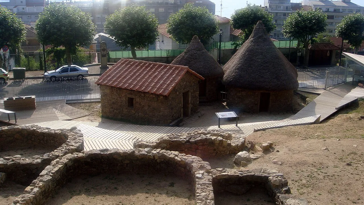
The castro settlement
📍 Parque do Castro
Circular Iron Age houses with three reconstructed dwellings and explanatory panels. The literal origin of Vigo, open to the public since 2010.
An Iron Age settlement, a Baroque star fortress and the best viewpoint over the ría, all on the same hill and for the same reason: from up here you see everything coming.
🎧 On the walk Monte do Castro and the new townThere are hills that explain whole cities, and this is one of them. The people who founded Vigo settled on Monte do Castro twenty-six centuries ago, and two thousand years later the military engineers of the Spanish monarchy chose exactly the same spot for exactly the same reason: from up there you command the whole ría.
The stone circles you walk on up here are the floor plans of houses where people lived more than two thousand years ago. It is a castro, a fortified Iron Age settlement, inhabited from the sixth century BC until the second or third century AD, by then in Roman times.
They lived in round stone houses with thatched roofs, protected by walls and ditches, farming the slopes and going down to the sea to fish and to trade. Almost eight hundred years of continuous occupation on the same spot.
The whole of Galicia and the north of Portugal are scattered with castros: they run into the thousands and they are the oldest mark of identity in this territory. The Romans called this land Gallaecia precisely after the Gallaeci, the castro peoples who lived here.
What is surprising is how late it opened to the public. The hill was military land for centuries; it was not until the army handed it over to the city in 1934 that the excavations began, and the site did not open as an open-air museum — with three reconstructed dwellings — until February 2010.
Circular Iron Age houses with three reconstructed dwellings and explanatory panels. The literal origin of Vigo, open to the public since 2010.
Download the app and discover Vigo offline, whenever you like. Take the walking tour Monte do Castro and the new town with a local guide in your ear.
Find out more about Viavoy →Twenty-one centuries later, the thick, sloping ashlar walls of the Fortaleza do Castro answer a different technology: gunpowder artillery. Vertical medieval walls collapsed under cannon fire, so modern fortification made them low and broke the perimeter into bastions that cover one another.
Seen from the air it draws an irregular star with three concentric rings of walls, designed so that from any point the enemy could be fired on without leaving blind angles. It is the system known as the trace italienne, which dominated European military engineering from the sixteenth century to the nineteenth.
It was built in a hurry and in fear. The Portuguese Restoration War was under way, with Portugal fighting to separate from the Spanish Crown, and Vigo — right on the border and exposed from the sea — found itself suddenly on the front line.
Between 1656 and 1665 this fortress, the castle of San Sebastián and the wall that closed off the town were built at the same time, with distinguished military engineers such as Juan de Villarroel and the Grunenberg brothers drawing the plans. The castle of San Sebastián was eventually demolished, and Vigo's city hall stands on its site today.
The reason the castro people and the engineers chose this hill is the same reason everyone climbs it today: from the viewpoint the whole ría de Vigo opens up, one of those Rías Baixas that the sea pushed inland like a soft green fjord.
Below, the port with its cranes; opposite, the Morrazo shore dotted with white villages; to the right, the Rande bridge, beneath whose waters the galleons returning from the Americas laden with silver were sunk in 1702, caught by an Anglo-Dutch fleet.
Floating on the water are the bateas, wooden platforms hung with ropes on which mussels grow. They are what make this ría one of the greatest shellfish larders in the world, and the reason is geological: the Rías Baixas are river valleys invaded by the sea, with sheltered water and extremely high biological productivity.
And in the distance, closing off the mouth, the Cíes Islands, which the Romans called the Islands of the Gods and which are today a national park with access limited by permit and a daily quota. The best time to come up is sunset, with the sun dropping between the islands.
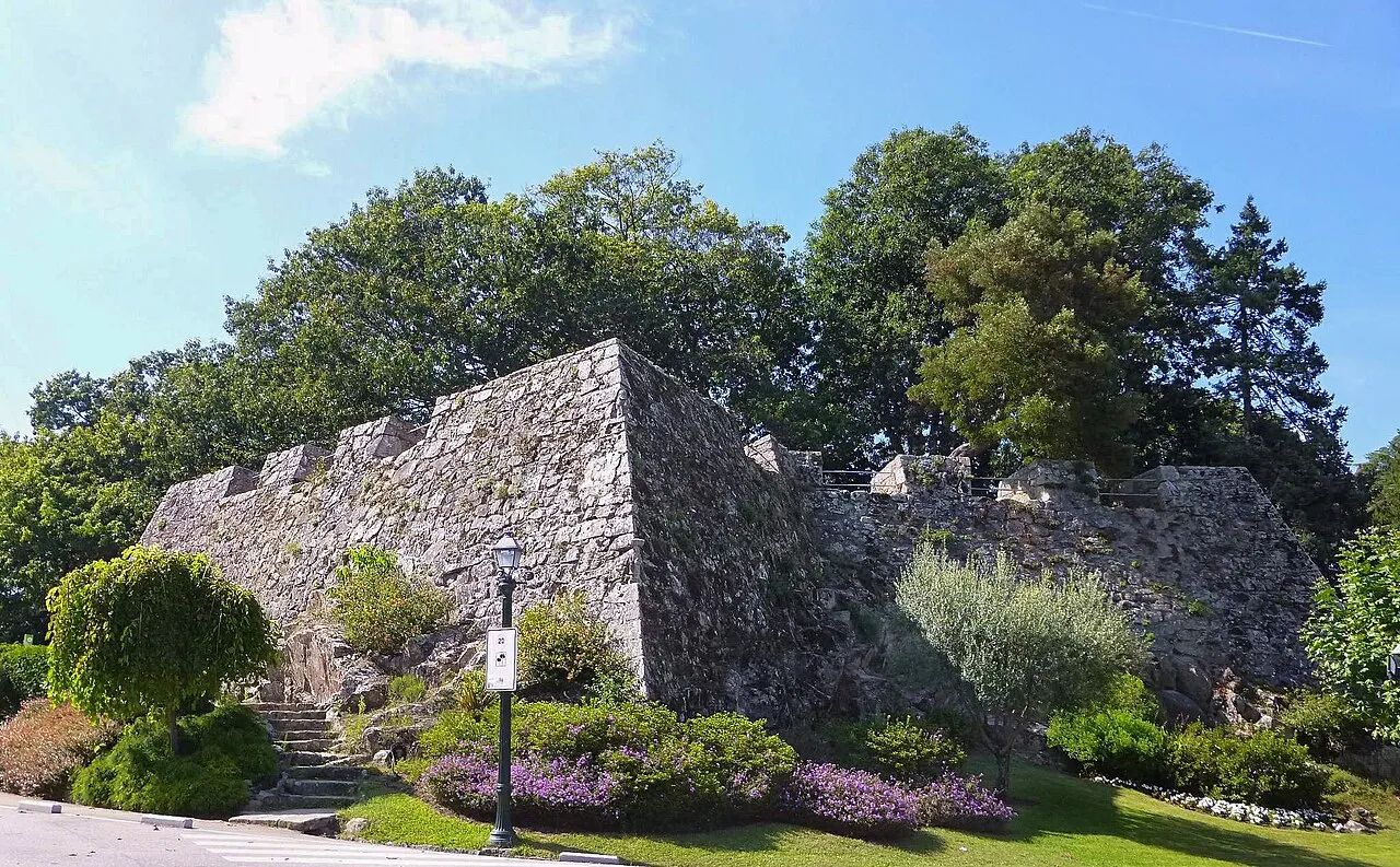
Baroque bastioned fortification of 1656-1665, with three rings of walls almost complete. You can walk it inside and out in twenty minutes.

The whole ría: port, Morrazo, the Rande bridge, mussel bateas and the Cíes Islands in the distance. Open access and the best view on the entire Galician coast.
A fortified Iron Age settlement, with round stone houses protected by walls and ditches, typical of the north-west of the peninsula. The whole of Galicia and the north of Portugal are scattered with them: they run into the thousands. The Romans called this land Gallaecia precisely after the Gallaeci, the castro peoples who lived here.
It was inhabited from around the sixth century BC until the second or third century AD, by then in Roman times: almost eight hundred years of continuous occupation. It is the literal origin of the city, even though it has only been open to visitors since February 2010, when it opened as an open-air museum.
Because it is a bastioned fortification, the technical answer to gunpowder artillery. Tall, vertical medieval walls collapsed under cannon fire, so they were made low, thick and sloping, and the perimeter was broken into bastions that cover one another so as to leave no blind angles.
Between 1656 and 1665, during the Portuguese Restoration War, when Portugal was fighting to separate from the Spanish Crown and Vigo found itself on the front line because of its closeness to the border. It went up at the same time as the castle of San Sebastián and the town wall, with distinguished military engineers drawing the plans.
The whole ría de Vigo: the port with its cranes right below, the Morrazo shore opposite, the Rande bridge to the right, the mussel bateas floating on the water and the Cíes Islands closing off the mouth in the distance. It is the view that sums up the city and probably the best on the Galician coast.
Floating wooden platforms hung with ropes on which mussels grow. They are what make this ría one of the greatest shellfish larders in the world. They work so well because of the geology of the place: the Rías Baixas are river valleys invaded by the sea, with sheltered water and extremely high biological productivity.
An hour and a half covers all three without rushing: half an hour at the castro settlement, twenty minutes walking the fortress walls and the rest at the viewpoint. The climb from the centre is about twenty minutes uphill, and there are taxis if you would rather save your legs.
Download Viavoy and walk Vigo offline, whenever you like.
Keep reading